Ula district is the closest district to the city center and is 14 km away. It is within 3 km of the Muğla – Marmaris highway. It is located almost in the middle of Muğla geography.
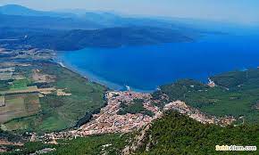
The district is surrounded by mountains on all four sides. It is adjacent to Menteşe from the north, Gökova Bay from the west, Köyceğiz from the east, and Marmaris from the south.
The dominant vegetation in the region is Mediterranean scrub and forest, and 65% of the district is covered with forests.
Climate
Mediterranean climate features are seen in the district. The summer months are hot and dry, and the winter months are warm and rainy.
Transportation
Since it is very close to the city center of Muğla, there is no problem in road transportation.
It is 75 km from Dalaman Airport and 94 km from Milas-Bodrum Airport.
History
Although there is no definite information about when the district was founded, it is estimated that it was founded in the 6th century BC, based on the findings in the ancient city of Kyllandos, which is 3 km away from the district center. In addition, “OLA” is among the cities mentioned in the agreement made between the Ionians and Carians in 1440 BC.
Ula is one of the earliest places to settle down. Ula, which established the municipality organization in 1895, gained the status of a district in 1954.
PLACES TO VISIT
• City Tour
• Close Sightseeing
• Ula Houses and Nail Çakırhan Architecture
• Akyaka and Gökova Bay
• Sedir Island – Kedrai
• Deer Canyon
Transfer from Dalaman Airport to Ula


